- NAME
- DESCRIPTION
- DATA OUTPUT
- USAGE
- CHANGELOG
- Horizontal maps moved to separate product, 2023-02-24
- New version 2.0 with vcross only, 2022-06-30
- Several IGA routes added: 2021-11-23
- New vcross route: 2019-06-28
- New vcross route: 2019-05-14
- 1.0 out of beta: 2019-05-14
- New products, back to beta: 2019-04-04
- Version 1.0: 2019-03-01
- Version 0.1: 2019-01-28
NAME
Routeforecast - Vertical cross sections for flight routes offshore and over land
DESCRIPTION

This service returns vertical cross section plots for flight routes offshore and over land,
given by ICAO ids.
Routes over land have the prefix iga.
The plot ENHF-ENBJ is generated from the Arome Arctic model,
all other plots are generated from the MEPS model.
Plots are updated every 6th hour, approximately at 04 UTC, 10 UTC, 16 UTC and 22 UTC, and are available hourly up to +18 hours.
DATA OUTPUT
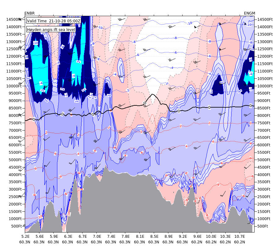
The plots are 2-dimensional, with flight path on the X-axis and altitude along the Y-axis (from SFC to 10,000ft for offshore routes, and from SFC to 15,000ft for routes over land).
Wind arrows indicate the direction and strength of the wind in knots. The wind direction is indicated as follows: North (360°) by arrows pointing downwards, south (180°) by arrows pointing upwards, west (270°) by arrows pointing to the right and east (90°) by arrows pointing to the left.
Isolines for temperature: blue for temperature below zero, red above zero, while the 0 isoterm is displayed as a black solid line.
The blue palette shows the density of clouds for degrees 0.2, 0.4, 0.6, 0.8 and 1, where 1 means completely cloudy. Darkest color indicates the highest density of clouds.
The multicolor palette shows icing intensity: dark blue = traces of ice, cyan = feeble icing conditions, yellow = moderate icing conditions, red = severe icing conditions.
The red palette shows the relative humidity for 70, 80, 90 and 100%, darkest red shadow indicates the highest humidity (only available over land)
The gray palette shows the terrain.
USAGE
Parameters
- route (required)
-
The ICAO codes for the start and destination of the route. Valid options are:
ENBJ-ENHF, ENGC-ENBR, ENGC-ENFL, ENHE-ENKB, ENHF-ENUJ, ENHF-Wisting, ENJS-ENZV, ENLE-ENZV, ENNE-ENBN, ENOA-ENBR, ENSL-ENZV, ENUN-ENBN, ENWA-ENBR, ENWA-ENZV, Stangnestind-ENKR, iga-ENAL-ENCN, iga-ENAL-ENRO, iga-ENAN-ENBS, iga-ENBR-ENGM, iga-ENBR-ENVA, iga-ENCN-ENRY, iga-ENFL-ENNM, iga-ENFL-ENTS, iga-ENFL-ENZV, iga-ENHF-ENKR, iga-ENHK-ENMH, iga-ENHV-ENSS, iga-ENKA-ENHF, iga-ENKB-ENGM, iga-ENLK-ENKR, iga-ENML-ENTO, iga-ENNM-ENHK, iga-ENOL-ENTC, iga-ENOL-ENTS, iga-ENRO-ENEV, iga-ENRO-ENLK, iga-ENRY-ENRM, iga-ENRY-ENTS, iga-ENVR-ENAN, iga-ENZV-ENCN, iga-ENZV-ENRO, iga-ENZV-ESSTNote: The routes list is dynamic and is subject to change without further notice! To get a list of currently available routes, use this method:
- time (optional)
-
Time of forecast in ISO format, e.g. 2019-01-15T12:00:00Z. A forecast is generated for every hour for up to 22 hours in the future.
If not specified, the forecast for the current hour is used. This parameter can be used on all methods.
Sample request URLs
https://api.met.no/weatherapi/routeforecast/2.0/?route=ENBJ-ENHF
https://api.met.no/weatherapi/routeforecast/2.0/?route=iga-ENML-ENTO
available
A list of available data may be retrieved using the 'available' method.
https://api.met.no/weatherapi/routeforecast/2.0/available
healthcheck
To check if any files that should be available are missing,
please use https://api.met.no/weatherapi/routeforecast/2.0/healthcheck (only available for internal users).
CHANGELOG
Horizontal maps moved to separate product, 2023-02-24
Due to increased demand,
the horizontal maps have been expanded with more areas and are now available via the Offshoremaps product.
New version 2.0 with vcross only, 2022-06-30
Due to lack of use and demand, production of the horizontal maps will end in September. Only the vertical cross sections will continue to be available in the new version 2.0.
Version 1.0 is now deprecated, and along with all horizontal products will be removed on 2022-09-01.
Several IGA routes added: 2021-11-23
In addition to the 12 offshore routes in vcross, we have now added 27 new routes over land. These are prefixed with "iga-".
New vcross route: 2019-06-28
ENJS-ENZV has been added
New vcross route: 2019-05-14
The route Korpfjell-ENKR has been added to the vertical cross section products. (No ICAO code has yet to be assignated to Korpfjell, hence the non-standard route name).
1.0 out of beta: 2019-05-14
No further changes planned, product considered stable and can be used in production.
New products, back to beta: 2019-04-04
Type Wave has been replaced with a similar but more precise product helicoptersignificantwaveheight (existing requests will be redirected). In addition two other new products have been added, helicopterlightningobservations and helicoptertriggeredlightningindex.
Due to constantly changing requirements we have added back the beta status for routeforecasts. Further changes may be expected, we do not recommend using this service in production environments unless in cooperation with MET Norway. We suggest subscribing to the Changelog RSS feed to be informed about further developments.
Version 1.0: 2019-03-01
New version released, with new products seasurfacetemperature and temperature2m. No longer in beta status.
Version 0.1: 2019-01-28
Initial prototype for testing. We will bump the version number to 1.0 when officially launched.